Yesterday, a weak upper level disturbance was approaching, with upward motion aloft, producing an unstable layer above the surface.
One sign of the upward motion was the development of cirrus, include some impressive fallstreaks (made of ice crystals). Several of you sent me pictures you took of this beautiful feature and several others were shown on the web (see example below from George Tanaka of Bainbridge Island--courtesy of Scott Sistek's blog):
The curved ice crystal "tails" falling from the cirrus are often called "mare's tails." Why are they curved? The reason is that the wind speed change with height--usually decreasing below the main body of the cirrus--thus the curve.
But as the day progressed the air at mid-levels started to convect into small cumulus, actually altocumulus. Some of these cumuli developed tower or turret shaped features--they are known as altocumulus castellanus. Now that is name that will impress your friends! Just say that casually at some party and it will turn some heads.
Here is a great video from the UW web cam that shows the destabilization of the mid-levels and the development of the convection, with some of it deep enough that rain started to fall out:
 Click for video Click for video |
| http://www.atmos.washington.edu/images/webcam0/movies/20110824.mov |
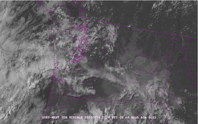
And you can catch the marvelous sunset.The instability clouds were apparent on the satellite pictures during the afternoon and afternoon:
An offshore band was particular impressive.
And an added features---Mt. Rainier developed a nice "cap" during the afternoon...a sign of moisture and lift aloft.
It is now clear that Hurricane Irene is going to savage the East Coast--a really serious storm. But for us, just the opposite. The warm, perfect weather will continue through Sunday, with perhaps a slight cooling on Saturday.
And a reminder---I will be teaching Atmospheric Sciences 101 this fall if anyone is interested. UW students, of course, and others who want to take it as non-matriculated students. Retired folks can get in for practically nothing.


No comments:
Post a Comment