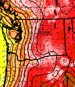
The fires around Ellensburg and Cle Elum are now slowly being contained, with a huge assist from the heat wave west of the Cascades. Ironically, the west-side heat and the associated thermal trough of low pressure has reversed the pressure difference across the Cascades, greatly weakening the strong winds over Kittitas County that allowed the fire to explode.
But everything is about to change...and not necessarily for the better.
Today clouds have inundated the coast and a shallow veneer of marine air pushed into the western side of the Cascades (see satellite picture Friday morning...you can also see some Asian smoke!).
The cool air will be mixed out and temperatures will soon surge into the upper 80s and low 90s away from the water. One last really hot day.
Tomorrow an upper level trough will approach and pass through our region late in the day (graphic).
This trough will result in upward motion and greatly increased instability, with the models suggesting a good chance of thunderstorms, particularly over terrain. A measure of the instability is something called CAPE (Convective Available Potential Energy)...think of it as the potential "juice" for thunderstorm. CAPE is a measure of the amount of buoyant energy that can be released when an air parcel accelerates upwards within a thunderstorm. This graphic for the predicted values of CAPE for 10 PM on Saturday shows a substantial amount for this part of the country:
Here is simulated cloud field for 5 PM Saturday...you can see the line of convective clouds/thunderstorms.
The trouble is that a lot of these thunderstorms will be high-based, meaning there will be lightning, but limited rain reaching the surface. The threat of lightning-caused fires is substantial.
But it gets worse. On Sunday, marine air will move into western Washington and the normal pressure difference will develop across the Cascades (see graphic). This should rekindle the strong northwest
winds descending into Cle Elum to Ellensburg. Here is a simulated vertical sounding with winds over Ellensburg for Sunday evening....strong NW flow near the surface.
Take a look at the precipitation forecast for the 24-h period ending 5 PM Sunday. If anything, these simulations tend to underplay the convective rain.
The fire folks need to be ready for all this....hopefully the Kittitas fires will not rev up again and lightning will not initiate many new fires. But a serious threat is there from both and the fire community must organize the resources to react quickly to damp down any lightning-caused fires.
More on this situation and the weekend weather forecast on KPLU.


No comments:
Post a Comment