I didn't want to mention this, worrying I might jinx it, but it is clear that August 2012 will the driest in Seattle history. So far we have had a trace--which means a sprinkle that is less than .01 inches. (The National Weather Service defines measurable rain as rain of .01 inches or more.) The previous record was in 1974 when .01 inches had fallen.
The other record we working on is the longest stretch of dry days----for which the record is 51 days.
Right now we are at 38 days...which I believe is something like the 7th longest dry spell. But it is clear that we have at least 4-7 days of no rain ahead, so we will surely get into the mid-forties.
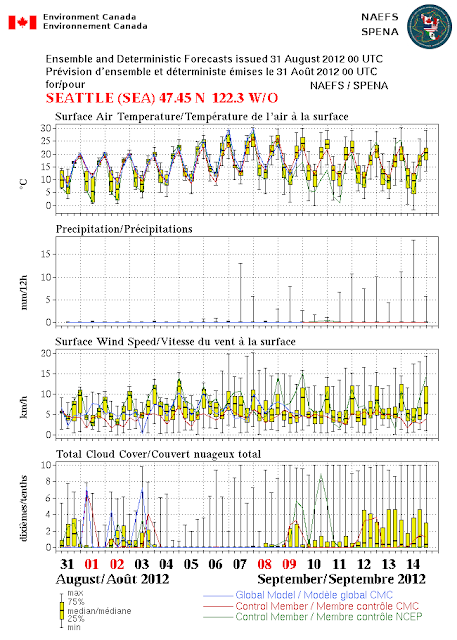
One of my favorite forecasting tool is from the output of the North American Ensemble Forecasting System (NAEFS), which combines the ensemble forecasts of the U.S. and Canadian forecasting efforts. Remember, an ensemble is when we run the models many times to get an idea of the uncertainty and probabilities in a forecast. Combining two ensembles is even better than using one!
So here is the output from NAEFS (keep in mind this is all in metric). Temperatures are moderate (highs around 20C--68F), but then warm well into the 70s and low 80s, as a major ridge builds in next week).
But look at precipitation in the second panel. Nothing for the next week...so we should get at least to a 45 day dry streak. We will be in the top five at that point. Within striking distance.
Finally, today and this weekend we have some weak troughs over the area, bringing some morning low clouds and temps in the upper 60s to low 70s. Fine for outdoor activities. As the ridge revs up this week, highs will rise in the mid to upper 70s, perhaps 80s in some locations. My tomatoes are very, very happy.
The only issue will be wildfires. There will be no lightning, so that won't initiate them. But the landscape of the region is very dry. Consider the MODIS satellite imagery from yesterday: many fires (and lots of smoke) over Idaho, and several fires over CA.


No comments:
Post a Comment