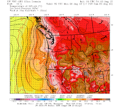
After a number of days with below-normal maximum temperatures, the Northwest is going to warm up for an extended stretch. Several days in the 80s and even some hope of hitting 90F in portions of the west. No, you are not dreaming.
But anyone wanting to be informed about northwest warm spells has to master the key feature of our warm periods: the thermal trough. I am very interested in thermal troughs...in fact, with support from the USDA Forest Service my student Matt Brewer and I have a research project on this topic.
If you look at a climatological pressure chart for the summer, it looks something like this. High pressure over the Pacific Ocean and lower pressure over the HOT southwest deserts and Mexico. Hot air is less dense than warm air and this results in less pressure at the surface. Yes, many of you think of low pressure being associated with cold, cloudy weather, but believe it or not, areas of very warm temperatures can be associated with low pressure as well. Sometimes we call these features heat lows or troughs.
In this kind of pattern, the coastal portions of the NW stay cool...higher pressure offshore and lower pressure inland forces onshore flow, and the ocean is cold. Sorry, that is the way it is. Natural air conditioning.
But sometimes..like this weekend...a miracle happens. A lobe of high pressure extends inland of us, forcing offshore flow. This offshore (easterly) flow starts over the heated interior of the continent and then gets even warmer when it sinks down the western slopes of the Cascades. The result is that a tongue of warm air extends northwestward out of the southwest--generally northward from the interior valley of CA or the intermountain West---towards our region. Each day it moves farther northward and strengthens. And since warm air is less dense, a pressure trough (area of low pressure) extends northward with the warm air. Want to see an example? Here is one from a paper Matt and I have written (you can see the pressure lines and temperature--shading).
Now we call this feature a thermal trough, but we really should term it a thermally induced trough, but that would have a little too racy an acronym for conservative meteorological journals.
A thermal trough is about to develop over western Oregon and Washington. Let me show you with the latest simulation. Each figure will present sea level pressure (solid lines), surface winds, and lower atmosphere temperature (shading).
Today at 5 PM...the normal situation.
Tomorrow at 11 AM. High pressure building inland. Easterly flow over Oregon...a thermal trough is starting!
Saturday morning at 5 AM. A nice thermal trough in western Oregon and its moving into western Washington.
Saturday at 5 PM. WOW. Huge, warm thermal trough extending into western Washington. Heat wave. Temperatures certainly in the upper 80s away from the water.
Thermal troughs don't last forever. Eventually the supporting inland high pressure moves eastward and the trough jumps into eastern Washington. This happens during the day on Sunday:
Don't worry, Sunday should be plenty warm--in fact, I expect it to be the warmest day...typically the day the trough moves across the mountains is the warmest day of the sequence. Could well have lower 90s from Seattle southward. Here is a model surface temperature forecast map for 5 PM on Sunday. Close to 100F in southeast WA and of course Portland and the Willamette...isolated from the water...are much warmer than Seattle. Water greatly moderates the temps over NW WA and the coast.
Thermal troughs not only bring warmth. Often the heat results in poor air quality (high ozone), and thermal trough passage over the mountains can really rev up any wildfires that are smoldering. Thermal trough passage causes big wind shifts that can play havoc with wind energy predictions. You can see why we are studying these troughs...they are important for a number of reasons!
And to really warm your hearts, here is the latest 8-14 day forecast by the Climate Prediction Center. Above normal over much of the west...except for the WA coast.
Climatologically, this is the warmest, driest time of the year...there is a reason SeaFair is this weekend.


No comments:
Post a Comment