Here is plot I made using the Puget Sound Clean Air Agency website that provides air quality information for the last two weeks. The green and blue lines shows visibility at the surface at Seattle Duwamish (purple) and Port Angeles (green) You will notice an increase starting around July 6 to a peak two days ago and then a subsequent drop. That probably was the result of the Asian smoke mixing down as well as an increase in low level moisture from onshore flow. You see the big spike in Seattle late on the 4th? You know what that is! Fireworks. But visibility degradation has not been the only impact of Asian smoke, ozone levels have been rising..in some locations by a lot. The red line shows ozone at the Cheeka Peak observatory near Neah Bay. You notice the steady increase in ozone early in the month and the decline the last few days? That ozone increase probably had an Asian origin.
In some locations the fireworks signal is just huge....some locations must get really smoked up. For example, I have plotted a collection of suburban and rural communities below. Marysville is simply OFF THE CHART. You know what is near there! The Tulalip Indian's mega fireworks store and shooting area: Boom City. Don't go near there on July 4th if you have asthma...
 |
| Typical fun at Boom City |
Whistler is seeing levels as high as 90 ppb O3, and preliminary CO data is showing CO peaks of 400. Pm2.5 levels in Vancouver are double their normal levels (no exceedences) and visibility is significantly impaired. There are both O3 and PM advisories in effect in the interior of BC. We're expecting more plume impacts in the coming days from the satellite data. Impacts appear to be possibly larger than in 2003.
( 90 ppb--parts per billion-- is VERY high. CO is Carbon Monoxide. Pm2.5 is a measure of the amount of small particles and visibility)
Meteorologist Eric Taylor, from the B.C. Ministry of Environment, says he has never seen ozone levels as high in B.C.'s central Interior as he has seen the last few days. Here is a link to a story and video about the Canadian impacts of the Asian smoke.
Now more evidence is available to prove the Asian pollution is heading our way. NASA has a cool satellite called Calipso with a scanning laser sensor (called a lidar) that shows where there are
particles and clouds (and smoke!). In a north-south scan off our coast on July 5th, the satellite documented smoke (black color) at an elevation of 3-10 km (see image, north is to the left). Pretty neat stuff.
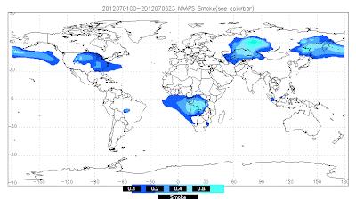
And the U.S. Navy has a system for tracking smoke, dust, and aerosols around the planet...here is their products for the first six days of July and the subsequent period until now....it is clear that Asian smoke is the culprit.
Now there are some significant fires in California right now and some lesser ones in eastern Washington and Oregon (see map).
The latest MODIS satellite imagery shows the smoke north of the Bay Area from the CA fires and if you carefully you can see a few eastern Oregon or Washington plumes. This promises to be a smoky season for the western U.S..


.jpg)


No comments:
Post a Comment