Last night an usual and spectacular display hit northern Kitsap to the northern Olympics. Here is an amazing picture supplied by Greg Johnson in Hansville. You can see virga (rain) falling out of the cloud near the lightning.
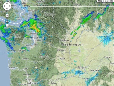
The current radar image, shown below, shows thunderstorms over the north Sound. More convection is over the northern portions of eastern Washington and the coast.
Why the thunderstorms? We start with fairly unstable air above the surface. In fact, you could see it destablizing during the evening last night with the formation of altocumulus castellanus clouds (castellanus indicating "castles" in the sky!):
A very tight closed low has moved into the region, with the center near Olympia (see graphic at 500 hPa...around 18K feet) that is rotating moisture northward in eastern Washington, eastward across the northern Cascades and NW WA, and then southward over the Olympics. It is also providing some lift. The key is NOT to have onshore flow through depth...that is death for summer thunderstorms west of the Cascades.
The low center also drove in more marine air at low levels...so quite a bit of lowland clouds this morning (see visible satellite image). It will burn off in most locations later.
The low will move out tomorrow, but the threat of thunderstorms remain...particularly over the mountains and eastern WA.
On Sunday a strong trough moves in that should cool us down 5-10F and bring in more low clouds. The Sunday pattern remains me of the one that produces snow in December...
OK...the perfect weather couldn't last forever...but is will be back by mid-week.
UPDATE:
Here is something fascinating. UW Atmospheric Sciences Grad Student Luke Madaus collected recent Twitter "tweats" that mentioned thunder for a few hours this morning and plotted the density of such messages on a map. Here it is. Lots of reports of Puget Sound and NW Washington!
And there are some samples of lightning reports...and folks, there has been huge amounts of lightning for this area.
First, for the half-hour ending 11 PM, Thursday....loads in eastern WA and some over the NW Olympic Peninsula
Ending 4:30 AM this AM...eastern Washington and lots over and near the Olympics
And this morning before 10 AM...an active line of thunderstorms over Puget Sound.


No comments:
Post a Comment