Snow Update on KPLU (88.5 in the Puget Sound area) at 9 AM Friday--Available on the Their Website
Yes, there has been lots of talk about lowland snow--enough to give local mayors insomnia. And some local TV stations are claiming that they have reports of snow on a few local hills. I bet Jim Forman of KING TV is getting his famous parka dry cleaned or something.
Right now the air over is cold, but really too warm for significant lowland snow. Here is the latest temperatures aloft from the UW SnowWatch system, which makes use of aircraft observations (ACARS) coming into Seattle. The blue dots are temperatures from the profiler system at Sand Point, which are not as dependable. The freezing level is around 1800 ft, which generally means the snow level is 800 ft, 1000 ft lower. Snow melts out in that 1000 ft. A really heavy shower could drive the snow level a bit lower.
Some showers are moving through right now, bringing rain to the lowlands and more snow to the mountains. Lots of snow. (see radar below). It is a bit colder in the NW part of the
state and there has even been some NE flow coming into Bellingham where they have had a bit of freezing rain reported. Seattle and the north Sound have been rainshadowed for the last few hours...so nothing fun there and the worst of the showers are moving to the south. The Langley Hill radar shows things quieting down offshore.
Tomorrow will be cool and dull, with a few chilly showers and not much more over the lowlands. Decent for the Occupy Seattle protestors and for the helicopters that are following them aloft. The fun waits until later Friday when a low center moves towards the SW corner of the state (see graphic at 7 PM Friday). Now normally I would be getting REAL excited when such a situation, which has a lot in common with major snow events in western WA, but there are problems for lowland snow lovers. The temperatures are still marginal at this point and the air to the north is not super cold. There is some leakage of colder air through Bellingham at this point though. The big problem is a lack of precipitation, with the upper level support (producing strong upward motion and precipitation) being weak.
Here is the three hour precipitation for the three hours ending at 7 PM Friday. Pretty sad.
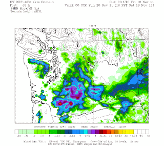
There is simply too little "juice" for this system. Here is the 24h snow predictions for the period ending 4 PM on Saturday. Some folks will get snow: the southern Cascades and the southern part of eastern Washington will get a nice white blanket and the northeasterly flow coming out of the Fraser valley will move southwestward and slam into the Olympics giving some snow to the foothills and the southern suburbs of Sequim and Port Angeles. And some odd snow showers here and there.
But now the warning and why we need to stay alert. As the low goes by the temps will cool enough for snow over most of the lowlands. If the precipitation is heavier than forecast there could be considerably more snow over sections western WA.
And another warning...the models have been consistently suggesting a strong pineapple express with very heavy rain in the mountains Tuesday/Wed. of next week. This will really mess up the snow at many of ski areas (the lower ones).
PS: Apologies to engaged retirees. In my previous analysis of the School Board race I speculated why the early voters supported the incumbents and suggested that non-engaged retirees might have been to partly to blame. There are certainly many highly engaged retirees who supported change in the District. Sorry.


No comments:
Post a Comment