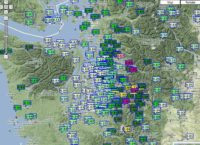
that nothing much is happening, but such a ridge brings warmer temperatures and strong westerly/northwesterly winds the produce heavy precipitation as they rise on the western slopes of the Olympics and Cascades. Many such windward locations have had 2-4 inches over the past day, with Spada Lake, northeast of Everett, receiving 5.9 inches in the 24h ending 4 PM today. Here is the 48-h precipitation from the UW/Seattle Rainwatch system. Huge amounts, over four inches along the slopes, while practically nothing fell to the SE of the Olympics. This is a profound rainshadow...the one that usually is over Sequim during southwesterly flow.
Take a look at the precipitation for the last 24h. A range from .01 inch near Hood Canal to 4.57 inches NW of Everett. Precipitation was actually lighter over the Cascade crest and then declined to virtually nothing on the eastern slopes of the Cascades.
The snow level has risen to the passes and the effects of heavy rain on the huge snowfall of the past week has set off avalanches, producing EXTREME avalanche danger above 4000 ft. I repeat extreme. SR2 and I90 have periodically been closed due to this threat, and in fact Stevens is now closed for the evening. Such heavy rainfall has resulted in the NWS putting out flood warnings for the Snoqualmie and Tolt Rivers draining the central Cascades, plus the Stillaguamish, Skykomish, and others.
The regional models have indicated this threat for a while; here is the 48h precipitation from a WRF run (our very highest, 1.3 km grid spacing) begun 4 AM on Monday. Reds indicate over five inches! And mamma mia...that is quite a rainshadow!
During the next few days the mountains will get hammered with snow, with the central to northern Cascades getting many more feet. But what about the lowland snow that folks have been talking about?
The truth is that it is getting less likely, the reason being that the trough over the Pacific is coming in from too westerly a position...not from the NW as associated with most lowland snowstorms in our area. Here is the latest 72 h upper level forecast (500 hPa). Not ideal.
It will get cold over the weekend, but a major lowland snow event does not look likely. Of course, we should watch the situation....
Let me end with some good dog news...no my little dog Leah is still lost in Mountlake Terrace, Brier, and northern LF Park. But a little beagle named Chunky has been found in the arboretum after being lost for two weeks, after a large effort by Chunky's owners, missingpetpartnership, and others. We can only hope that someone will see Leah one day...
 | |
| Chunky...back home again. |
 |
| Leah--still alive and being spotted. |
Remember: The NW Weather Workshop in Seattle on March 2-3. See information on the right panel.


No comments:
Post a Comment