I hate to say it, but for the next day the weather for the Olympics venues will be better for surfboarding than snowboarding. Heavy rain. Thick fog. Not luge, but deluge.
Lets face it. Our Canadian friends were mighty unlucky...a moderate El Nino at just the wrong time. And El Ninos are bad for snow. Since southern British Columbia weather is going to be a big topic for the next few days, so lets see what is going to happen.
First, as any good forecaster would, lets begin by looking at the latest satellite picture. A deep low center is offshore (see the spiraling clouds), with a juicy looking front in the offshore waters ready to move inland. Not good.

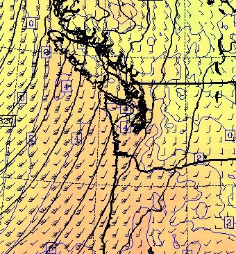
As shown in the figure below, which presents the winds and temperatures at 1 PM today at around 5000 ft, a strong current of warm air associated with the front will be aimed directly towards the Olympic venues. Those triangular barbs indicate 50 kt sustained winds and 4 indicates 4C or 39F. Way above freezing at elevations above nearly all Olympic venues.

And rain..you bet...here is the 24-h rainfall ending 4 AM tomorrow (Sunday). Looks like 1-3 inches of rain, not snow, at Cypress Mt.

 Warm rain with fog and strong winds. The ABSOLUTELY WORST conditions for maintaining a snowpack.
Now let me show a forecast product I have never used on this blog...a time-height cross section (for Vancouver, CA). A very important tool for meteorologists. The x axis is time...in GMT: 1312 is today at 4 AM, 1400 is today at 4 PM, etc. The y-axis is pressure in millibars. Lower pressure is higher in the atmosphere. 850 is around 5ooo ft, 700 around 10,000 ft. The shading is relative humidity. Darker green...above 90%. Think clouds and fog. Red gives temperature (in degrees C) and the winds are shown by those barbs (they point to the direction the wind is going, big tail lines-10 kts, 3 of them-30 kts, etc). You are now trained.
What do we see? First, the air is saturated and moist until tomorrow at 4 AM Sunday. Strong winds developing from the south. The freezing level climbing to 6000 ft or more.
WETAPPOCOLYPSE! FOGARMAGEDDON!
What will happen when all the sawdust and hay base at Cypress Mountain gets saturated? I don't want to even think of it. The first snow/sawdust avalanche in history?
 Anyway, it is going to be a bad day at the Olympics today. But you can see that after the front moves through later tonight the air will dry out considerably and the freezing level will drop to below 5000 ft. Helpful for Whistler but still way too warm for Cypress Mt. The only snow there are going to get is snow they truck or helicopter in.
Whistler has plenty of snow, even though the lower elevations around the village are marginal. And there will be more high elevation snow this week.
But there is one weather feature that is really going to impact Northwest and Olympic weather later this week. It looks like a HUGE ridge will develop on Thursday through the early weekend. No precipitation at all. Warm temperatures in the lowlands. Sun. And our gardens will surge forward again.


No comments:
Post a Comment