Sometimes having a boat (or getting a ride on one) is the ticket for getting some sun, and that approach is often useful in the spring here in the Northwest. The spring is the time of maximum instability of our atmosphere, the time when we see the most convective cloud and showers. The reason is clear: spring is when we have the maximum change in temperature with height. The atmosphere is still fairly cool, while the sun is near maximum strength and thus can effectively warm the surface. When the temperature change with height gets large enough, the atmosphere starts percolating (or convecting), with the upward moving air producing cumulus clouds.
Since the water does not warm quickly, there is little of this cumulus activity over local water bodies. Today's MODIS satellite imagery shows this very clearly. The picture above shows the 1-km resolution image from MODIS (the Aqua satellite), lots of clouds (cumulus) over land, but little over the Strait and the Pacific coast. You will notice a thin strip of the coast is clear; that is the zone influenced by the cool air over the Pacific at low levels.
Here is an even higher-resolution view (250-m resolution). Clouds tend to form preferentially over the higher terrain, and valley bottoms are often relatively clear. If you look closely, you will see some clouds forming over some of the bigger islands such as Whidbey and Orcas.
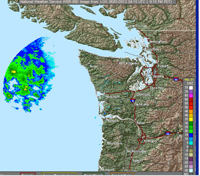
A weak frontal system is now approaching our coast...the Langley radar near Hoquiam shows it for offshore at 9:40 PM Friday night: We will see increasing clouds from this system Saturday morning and light rain should be generally limited to the northwest portion of the State. The situation should improve later Saturday as this feature moves eastward. Generally dry weekend for most.


No comments:
Post a Comment