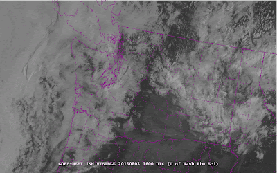
Saturday started with a a lot of low clouds over the Northwest, but it is really interesting to see how they burned off in time, and as we will see some of this is greatly influenced by local sea breeze circulations.
Let's begin at 9 AM (1600 UTC). Lot of clouds!
At 11 AM (1800 UTC), they are thinning over the Sound and up towards Bellingham. Over eastern Washington the layered, relatively uniform clouds are also thinning and being replaced by more speckled cumulus type clouds as the surface warms.
Jumping forward to 2 PM, some major changes have occurred. The clearing over the Sound and waters north has intensified and some thinning has occurred just offshore of the Pacific coast.
An hour later (3 PM, 2200 UTC) the coastal and inland overwater clearing is nearly complete. But interestingly the clouds over land have thickened. A bummer for those having outdoor barbecues during the afternoon.
How do we explain this strange behavior? Think sea breeze!
Many of you know a bit about sea breezes. The land heats up during the day compared to the water and this forces onshore flow, known as the sea breeze (see schematic below). But what you might not have learned is that there is a circulation in the vertical with the sea breeze (air has to come from somewhere!) Air rises over land, moves seaward aloft, and then sinks over the water. As a result, the sea breeze circulation enhances clouds over land (upward motion produces clouds) and clears the skies over water (sinking air works against cloud formation).
Saturday was a day without a lot of weather action (fronts or storms, weak pressure differences) so the sea breeze was very evident. Plus, the sun is strong now, which is good for producing sea breezes.
Along the coast, a sea breeze developed during the later morning and early afternoon, something shown by the wind speeds measured at the surface at Westport along the cental WA coast (see figure, time in UTC, later to the left, 18 is 11 AM, 20 is 1 PM, etc, speeds in meters per second).
As the sea breeze developed, there was sinking air offshore that melted away the clouds. And the rising air inland helped maintain the clouds there. We can even see proof of this vertical circulation! There is a device called the radar wind profiler run at Westport by NOAA ESRL. It shows the winds with height every hour. Here is the plot of the winds there in time (height in kilometers, time in UTC on the bottom). Look carefully and you will see the winds become northwesterly at low levels with easterly winds (from the east) developing around .75 km. So there is an onshore (westerly) component at low levels and an offshore (easterly) component aloft, consistent with a sea breeze circulation.
Here is a schematic of the situation.
What about the clearing over Puget Sound? A double sea breeze develops there, with air moving from the Sound to the land on both sides at low levels (see schematic). Air sinks over the water, giving clearing, and rises over land, maintaining the clouds. We see such clearing occurring over the Sound on many spring and summer days...this is the reason it happens.
You can see the dual sea breezes over Puget Sound from the WSDOT/UW Ferry Weather website (see below). You will note easterly wind sover the western Sound and westerly winds over the eastern Sound...the difference is produced by the sea breeze (helped by upslope flow on the Olympics and Cascades).
Coastal and overwater clearing is observed throughout the world and the mechanism is the same as shown above.
Seattle School Board Race
This is important for those of you in Seattle. You have a choice between Sue Peters, strong math advocate with years of experience in the district, or Suzanne Estey, an individual with essentially no experience with Seattle Schools and who is supported heavily by billionaires and millionaires (like Microsoft's Steve Balmer) who are pushing for Charter Schools, endless testing, and a weak school board. Sue Peters is the far better choice.


No comments:
Post a Comment