WSDOT photo of a big tree blocking parts of I5
First, what were the wind speeds like? Here is a map of the max winds during the past 24 h; virtually all of the high winds occurred this afternoon. Plenty of folks experienced gusts of 30-45 mph, with some marine locations to 50 or a bit more. Interestingly, the winds were worse over the inland waters than along the coast. Strong winds are a problem now because trees have their leaves and thus are more prone to catching the wind. Furthermore, this has been a pretty wimpy windstorm season, so there was only modest "pruning" by winter winds.
During the morning it became clear that we were in for something special. The coastal radar at Langley Hill showed an intense convective band approaching the coast, as shown by the image below at 10 AM. You will also notice a second band behind it.
The UW WRF model forecast substantial winds during the afternoon (gusts reaching 25-35 kt, see below), although it did underplay them by 5-10 mph in places. That is unfortunately typical.
The convective line reached the Puget Sound lowlands around 12:30-1 PM and was associated with intense rain and some lightning. I was teaching my forecasting class at the time and let's say none of us were giving full attention to the lecture. Visiblity plummeted to a few hundred feet in the downpour and driven by the winds, water pushed through the closed windows of my lecture room (dripping to the room below on to some computers!).
Here is the radar image right before it hit the UW (1:20 PM). Pretty impressive line. You don't see reds (very, very heavy rain) on Northwest radar imagery very often.
Winds picked up modestly with the first band, but the REALLY strong winds followed the second band, which was not associated with much rain. Thus, this front was distributed over two steps, each associated with a rain band. Here is a plot of the weather at the UW to illustrate. The top panel shows sustained winds at gusts. The sixth panel is rainfall. A short spike of wind with the first band (around 21z), but the real winds were later (around 00z--5 PM) following the second band.
Why the sustained strong wind behind the front? Because a large north-south pressure difference set up behind the front as its associated trough of low pressure passed to the north (see graphic).
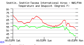
The air behind the front is cooler and much drier, with far lower dew points. It almost feels like fall outside right now. Here is a plot of temperature and dew point the last few days at Sea Tac. The dew point dropped from 55 to 42F today. You will notice that. And temperature is down to the lower 50s.
Tomorrow will be a sunny and cooler day, but temperature should still get into the mid-60s. After the torrid, dry weather of the past few weeks, this is almost welcome.


No comments:
Post a Comment