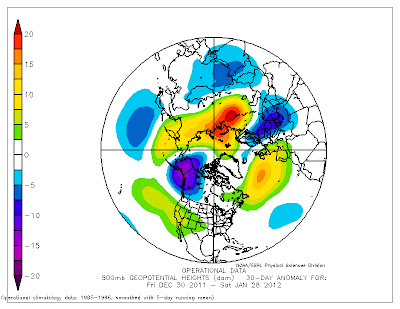
The weather is rarely normal and most years there are some large excursions from average conditions, but this year is rapidly becoming memorable over the eastern two-thirds of the country and Alaska.
In much of eastern U.S., winter hasn't really taken hold, with record maximum temperatures occurring on many days, and monthly averages being way above normal. Here are the anomalies (difference from normal) of the daily-average temperatures across the U.S. for the past 90 and 30 days (see below). For the last 90 days nearly all locations over and east of the Rockies has been much warmer than normal..with some places of the the northern plains as much as 8F above typical temperatures. That is really large. Guess who has been cooler than normal? The western side of the Pacific Northwest. We can't win! Cooler than normal temperatures have extended down to coastal CA and the far southwest, chilling those poor golfers and retirees in Palm Springs and Tucson.
The last 30 days has shown the same pattern,except that the warmth over the upper plains and Rockies have became even more accentuated.
To illustrate, here are the high temperatures across the U.S. yesterday. 60s in NY and New Jersey and 30s into the northern plains.
While most of the continental U.S. is mild and comfortable, western Alaska is having one of their coldest years on record. My colleague Mark Albright (past WA state climatologist) noted that Fairbanks during January 2012 is on track to be the coldest January in the past 40 years. King Salmon at the head of Bristol Bay is running -24 degrees F below normal for the month so far with an average temperature of -8 F. The coldest January on record averaged -3 F in 1956 at King Salmon where records go back 68 years to 1955.
80 miles west of Fairbanks at the confluence of the Tanana and Yukon Rivers lies the town of Tanana. After a low of -58 F yesterday followed by a high of -47 F, today is even colder with the latest reading of -60F this morning. Even more amazing, the Jim River site (180 miles N of Fairbanks) near Prospect Creek reported -77 F this morning. Prospect Creek holds the record for coldest place in the United States at -80 F on 23 January 1971. Yes, they were within 3F of the COLDEST TEMPERATURE EVER OBSERVED OVER THE U.S.
Now what is the cause of this? A very disturbed atmospheric flow configuration. Here are the anomalies...differences from normal... of the heights of the 500 hPA pressure surface (about midway up in the atmosphere). Ridging (higher than normal heights) over much of the U.S. and an anomalous deep trough over Alaska and western Canada. A very persistent pattern.
According to the National Weather Service's Climate Prediction Center this usual situation is not over yet. Here are the predictions for the next 6-10 days. MUCH warmer than normal conditions over the much of the U.S. (even us) as well as being considerably drier than normal. Cooler than normal over Alaska and southern Florida.
The reason...the U.S. ensemble systems are going for a BIG ridge over the western U.S. Here is the prediction for Friday at 4 PM for 500 hPa heights. The European Center forecasts (the gold standard) show the same thing...after Thursday the weather over the western U.S. goes dead.
We have a few wet weather systems to get through before then...starting tomorrow morning... but no lowland snow or major storms. We now have only a month left of western WA winter---after the 3rd week of February the worst is almost always over the lowlands. The sun becomes stronger, bulbs push up, and the lawns need to be mowed again. And yes, we can start thinking about those tomato plants.


No comments:
Post a Comment