A number of you have asked about the upcoming winter: can we get a fix on its general character?
For winter forecasts, you got to wait until one gets sufficiently close...and we there now. Sort of like waiting until you see the "whites" of its meteorological eyes.
Why do we need to wait?
To be honest there is only one useful tool for predicting seasonal weather around here and that is the correlation between El Nino and La Nina and our winter weather. The cycle from El Nino, through neutral years, to La Nina is called ENSO--El Nino Southern Oscillation. The problem is that there is a "spring barrier" to forecasting ENSO...there is very little skill for forecasts made in March through May for the upcoming winter, but skill increases rapidly in the summer.
Below is a graph by UW scientist Todd Mitchell that illustrates this fact.
It is a little intimidating, but be patient with me. The graph shows the correlation of the tropical sea surface temperatures (SST) in one month with SSTs for subsequent months. Tropical SSTs in the central Pacific (the Nino 3.4 area) is a measure of ENSO (El Ninos are associated with above normal SSTs, La Ninas with below normal SSTs). The correlations between the tropical SST for a month and subsequent months is shown by the shading, with yellow and red indicating high correlations.
In March or April the high correlations only extend about a month, but in July it extends for SEVEN months. So whatever the tropical SST is like now tells you a lot about what it will be for at least a half-year ahead (that is what is mean by the term "autocorrelation."
So, lets do some long-range predictions!
First, lets examine the recent trend in the sea surface temperatures in that crucial central tropical Pacific area (see graphic). Temperatures are slightly (roughly .2C) below normal...this is what we would consider neutral conditions. And the graph shown above by Todd Mitchell suggests this might continue for a while.
We also have some numerical and statistic models that predict what will happen to ENSO. Here is what they are suggesting (see plot). Nearly all are going around zero temperature anomaly, implying neutral ENSO conditions.
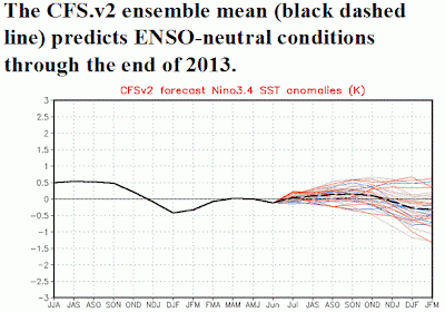
The National Weather Service also runs their coupled ocean/atmosphere global model out for many months (the CFS system). Here is the results for the tropical SST. Neutral conditions again.
So it looks like we are going to be in a neutral ENSO situation this coming winter, neither El Nino nor La Nina. The tropical sea surface temperatures will be close to normal.
What does this imply? El Nino years tend to be warm and less stormy. La Nina years are colder, wet, with more snow. Neutral years tend to be...normal. But there IS a tendency for the rare superstorms (like big atmospheric river floods) to occur in neutral years. This past year was a neutral year....and really wasn't too bad. La Nina late winter/springs are brutal...cold and wet last forever. And remember there are no guarantees here...just a weighting of the probabilities.
COSMIC-2
In a recent blog I talked about the importance of GPS weather satellite like COSMIC and the fact that NOAA and Congress appears to turning down the chance to work with Taiwan to launch the next generation of these satellites, with Taiwan paying for half the bill. Really bad move--we critically need the data. You can ask your representatives in Congress to support COSMIC-2 by going to this web site and providing your name and email. Thank you...its important.


No comments:
Post a Comment