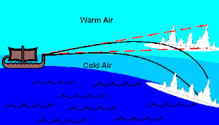
Superior mirages are most frequent during our summers near one of the water bodies (Puget Sound, the Straits of Georgia/Juan de Fuca, the Pacific) for a good reason: they are dependent on the existence of a large temperatures differences (increases) above the surface. In this case with cold water near the surface chilling the surface air, and much warmer air above, resulting in a strong inversion. Friday (Sept. 07) was an excellent day to look for such mirages, with the Sound being around 50F, while 80-90F air was over land and moving over the water, particularly near the coast.
Cold air near the surface is more dense that the warmer air above, and the change in densities create a lens-like effect in the atmosphere that produces the mirage (see schematic below). My weather book has a long section on how this works.
We are fortunate to have a wonderful mirage observing location: the weather station and multiple web cams run by Greg Johnson of Hansvile, who supports a marvelous website that is hugely popular among the region's weather lovers: http://www.skunkbayweather.com/
His location, on the water along the north side of the Kitsap Peninsula, affords a unique view mirages that provides something that ones rarely sees: video animations of the development of superior mirages during the day that allow one to appreciate the temporal variation in such optical effects. And with Greg's permission, I will show you some examples in this blog.
Take a look at a video (showing only every 4th frame that was recorded) from Greg's home at Hansville across the Sound towards Whidbey Island and it Bush Point (see map, Lighthouse is at Bush Pt).
The video starts in the morning when the air over land is relatively cool, but watch what happens as temperatures warm up aloft and the temperatures above the ground increase. If you have motion sickness, beware! The imagery is going to heave and distort in time. Click on the image or use the link to see the video.
At first things seem normal, but then the water seems to rise over Bush Point, the buildings grow into towers, and if you look closely you will see major changes in the terrain far to the north. If you would like to see the full resolution video, with every frame shown, go here. The effects get larger during the day as the air warms and tend to lessen during the evening.
Here a few still samples of impressive mirage features from that day. Over a few minutes, the changes can be substantial, here are two pictures take 6 minutes apart (7:50 and 7:56 PM). The changes in the atmospheric structure resulted in significant vairiationin the atmospheric lensing....look at the mountains...they look REALLY different.
Here is a wonderful example of the superior mirage effect, with the buildings and features along the coast rising into huge towers.
And miraging looking at a different direction:


No comments:
Post a Comment