Each run of our computer models have been moving the low southward, and particularly the areas of big pressure gradients, which are associated with high winds. Let me show you a sequence of pressure forecasts from the UW WRF model for 10 PM tonight, 1 AM tonight, and 4 AM tomorrow morning. At 10 PM a 973 hPa low is offshore our coast, but the area of very large pressure gradient (change) is offshore and swings towards the Oregon coast. Expect big winds (gusts above 50 mph) along the Oregon coast at this time.
Three hours later, the area of strong pressure gradient slams into northwest Oregon...this will be a major wind event for them: expect power outages and tree damage. The coast could have sustained winds of 30-50 mph, with gusts of 50-80 mph. This is serious...stay inside if you live there. The Willamette Valley will also get major, but lesser winds: sustained of 20-40 mph and gusts to 50-60 mph. Strong winds offshore of the the WA coast, but nothing really over the Puget Sound lowlands and NW WA at this time.
Then as the low moves inland, strong southerly winds will move northward into SW Washington, roughly from Seattle southward. In addition, with a huge east-west pressure difference, a strong westerly wind surge will push eastward into the Strait, where winds could gust to 40-60 mph (from the west).
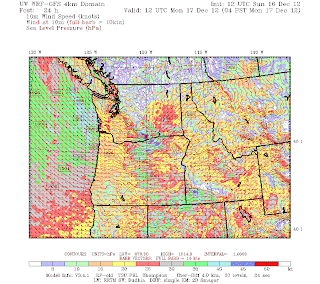
Here are the near surface sustained (NOT GUSTS) winds forecast by the modeling system (at roughly 30 ft above the surface). Red are sustained at 50 kts.
At 10 PM big winds offshore and extending to the Oregon coast.
Three hours later they move to the WA coast and the Willamette Valley.
And you can see the spread of moderately strong winds up to Seattle and into NW Washington by 4 AM. Seattle may see 20-30 mph winds over land and double that over the Sound.
So, the bottom line: this is a major event for the NW Oregon and SE WA coasts and the Willamette Valley. Seattle will get winds, but it will NOT be one of the big ones here (not the Chanukah Eve storm). The Strait will also have major westerly winds.
We can check the model runs this evening for a final confirmation. And yes, there will be huge snows in the mountains. Here are the 72hr totals for the period ending 4 PM on Wednesday. MANY FEET.
When the atmosphere has juice, like in this event, everything seems to happen. I almost forgot! They will be a fairly major easterly wind event on the western foothills of the Cascades (Enumclaw, North Bend, you know what I mean). Winds gusting to 60 mph+ tonight!
So enjoy the storm, but prepare for power outages and stay inside during the big winds.


No comments:
Post a Comment