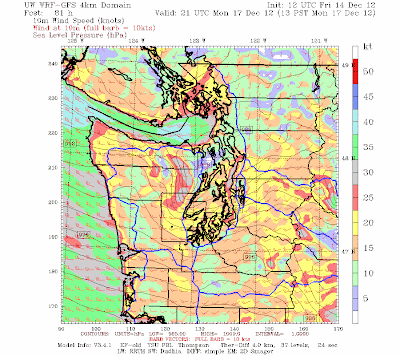
Saturday afternoon update: the latest runs are pushing the strongest gradients southward, which would lessen the strength of the storm from Olympia northward...more after the next runs....cliff
I waited to mention this issue on the blog, but it is now looking like we will have a significant wind event over the coast and western Washington on Monday, particularly during the morning.
The cause? A fairly deep low pressure system that is forecast to move across NW Washington and southern BC.
The models were all over the place yesterday, but today the European model, generally the most skillful, and the American GFS model are pretty much on the same page; this gives us more confidence in the forecast.
Although powerful, this system is NOT in the same class as the Inauguration Day Storm (1993) or the Chanukah Eve Storm (2006).
Here are the 12-km resolution runs (sea level pressure given by the solid lines) from the UW WRF model (driven by the NWS GFS model).
At Sunday at 10 PM a 976 hPa low is off Vancouver Island, with an intense pressure gradient (change in pressure with distance) west and south of the low.
By 1 PM on Monday, the low moves just north of Washington and an impressive pressure gradient is now over west Washington. Strong pressure gradients drive powerful winds.
Let's look at the wind speeds predicted by the UW model. Here is the prediction for sustained (few minute average) winds at 7 PM on Sunday BEFORE the low gets here. As typical in such situations, Northwest Washington gets hits hard first...sustained southeasterly winds of 35-40 knots, with higher gusts from Port Townsend towards Victoria.
At 1 PM on Monday, strong winds are found over much of western Washington, particularly over Puget Sound, through the Strait of Juan de Fuca, and along the coast. This is an example of a westerly wind surge through the Strait, following passage of a low-pressure system (I am writing a paper on this topic right now!)
And did I mention the snow ? Here is the 72-h snowfall forecast for the period ending 4 PM Monday. Two feet in much of the Cascades and Olympics, and significant snow in eastern Washington and Oregon. Even parts of the western lowlands gets a dusting! We have better snow conditions than anywhere else in the country. Forget Utah and Colorado...save your money and enjoy local skiing.


No comments:
Post a Comment