Light snow has been observed at Bellingham, Shelton, Olympia, Chehalis, Vancouver (WA), and Portland. The most snow apparent on regional cams is around Vancouver, WA:
The culprit: a weak disturbance moving southward down the coast and relatively cool air over the interior.
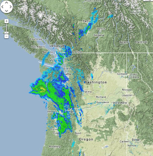
The latest radar shows the precipitation pattern. On the coast, the precipitation is rain, and the interior stuff is quite light. Seattle should stay dry, as should eastern Washington. We do not have super cold air over us, but evaporative cooling is allowing the snow level to drop to the surface in some locations.
Here is forecast surface chart for 10 AM this morning. You can see the low (solid lines are pressure) off the southern WA coast, and the temperatures (at around 2500 ft, shown by shading) indicated the cold air over eastern Washington and cool air over the western WA lowlands.
This is NOT going to be big snow event. Here is the model forecast from this morning, showing the 24-h total snowfall prediction over the region. Not more than about 1-2 inches in the most favored zones. Nothing over the Seattle Metro area (sorry, Jim Forman). Portland gets some white stuff.
But one piece of good news...after this low moves south of us, expect a lot of sun on Tuesday. New Year's will start on a bright foot...an excellent omen for the new year.


No comments:
Post a Comment