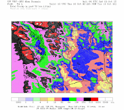
As you know, we have had virtually no rainfall over the region since late July, resulting in many drought records at locations on both sides of the Cascades. Now take a look at the forecast predicted by the UW WRF model for the 72 hours ending at 5 AM on Tuesday (both regional and WA views, click to get a larger image). In the Olympics, north Cascades, and southwest BC terrain (particularly Vancouver Is) amounts reach 5-10 inches, with a few higher values on the windward slopes. Wow. Although rainshadowed by the Cascades, even eastern Washington gets significant rain. Sequim, Port Townsend, and nearby will receive less rain, being in the Olympic rainshadow.
At this point, the hydrologists at the National Weather Service are not going for any flooding, since the rivers are starting out so low and land is bone dry, but one drainage is predicted to hit about 90% of bankfull...the infamous Skokomish River: That river is extremely flood prone due to logging.
The reason for this abrupt change in weather is a major shift in the large scale atmospheric flow pattern. Let me show you the upper level pattern (500hPa--around 18,000 ft) average over five days centered on last Friday at 5 PM. The black lines are the heights of this pressure surface and the winds parallel the black lines (ignore the colors!). Huge ridge over the northeastern Pacific. Where the lines are packed together the winds would be strong..the jet stream..and that was heading into Alaska. Wet times in Alaska.
Now lets look at the same fields centered tomorrow (Sunday) at 5 PM. See the difference? The ridge is gone and now the jet stream is heading right into us...and the jet stream brings the storms. And the rain.
Well, what about the upcoming week? Here is the same upper level plot centered on Wednesday afternoon. That pesky jet stream is here to stay for a while and our weather is returning to normal.
Good for our water bills, good for our forests and street trees, and good for those tired of the pressure of thinking you needed to be recreating in the mountains or bike paths. You can balance your checkbook now.
Finally, rain is not the only thing coming back...strong winds will as well. But these winds will be localized: along the coast and over the waters of NW Washington. Here is a WRF forecast of near-surface sustained wind speed for Sunday at 11 AM. No big deal over Seattle.
And if you are desperate for sun, it will be available today and much of tomorrow in eastern WA.


No comments:
Post a Comment