Sandy is now a category 1 hurricane with estimated maximum sustained winds of 85 mph and central pressure of 970 hPa (see picture). My community is all aflutter about this storm, particularly since our forecast models are not in agreement--some suggest the storm will intensify and head straight in to the Middle Atlantic coastline, some take it out to sea, and others move it out to sea before swinging it westward to hit New England or the Canadian maritimes.
 |
| Hurricane Sandy is not well formed at this time |
Let me illustrate.
First, lets start with the gold standard. The best hurricane prediction system is embarrassingly not American, but the European Center (ECMWF) high-resolution global model (note to U.S. Congressmen and Senators--you folks need to attend to this issue!). A model that has the equivalent of 15-km grid spacing over the entire planet.
You will not believe the forecast. Here is the sea level pressure analysis (solid lines, the shading is relative humidity) as the storm makes landfall along the Delaware coast. A 940 hPa low! That is very low.
And here is the associated wind field--sustained 50 kts plus over the ocean.
If this were true there would be major coastal damage. Most models tend to overdo such systems, but still, a huge threat.
But this is 2012 and we can do a lot better than a single "deterministic" forecast....there is plenty of uncertainty in the forecasts and one way we deal with that is with ensemble forecasts..running the model many times, starting a bit differently or with varying physics (e.g., different ways of describing clouds, precipitation, and the like). Ensembles are run with less resolution than the single high-resolution forecast shown above.
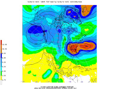
Here is the sea level pressure output from the ECMWF ensemble mean (the average of all the simulations) on the left side (solid lines) and the single high-res forecast on the right, both for 5 AM PDT on Monday, 29 October. The ensemble mean is a bit washed out (we are averaging the pressures of many runs and those diffusing things a bit), and the lowest mean pressure somewhat offshore of the high-res run. The color shading indicates that thelevel of uncertainty, based on the differences between the ensemble runs, is considerable.
Here is the same figure for 24 h later (Tuesday morning). The ensemble mean (left side) low center is making landfall on New England, but there is a lot of uncertainty. Clearly most of the ensembles are making landfall, but some forecast lows stay out to sea. The bottom line: a real threat, but it is not nearly 100%.
What about the American model, the GFS? Statistics show it is now tied for number two with the UKMET office model. Our high-res version (resolution about 25 km) does something very different (see graphics showing sea level pressure--black lines, and precipitation--shading). The storm stays offshore for a long time, bypassing the central Atlantic states and then swings towards the Canadian Maritime Provinces.
 |
| Saturday, 11 AM PDT |
 |
| Monday 11 PM PDT |
 |
| Wednesday 2 PM PDT |
 |
| Add caption |
By the way, what other famous storm started as a tropical storm, headed out to sea and then turned westward towards New England at almost exactly the same time of the year? Answer: The 1991 Halloween Storm....a.k.a. the Perfect Storm of book and movie fame.
So what do you come away with from all this? First, you know what it is like to be a meteorologist in a real-world, very serious situation. There is the potential for substantial loss of life, damage, and disruption. Large costs to protect assets. What would you recommend? This is why meteorologists make the big bucks (right!).
Our models..both high res and ensembles..indicate there is a real threat to the U.S., from roughly Virginia to New England. Folks in that region should pay close attention to the forecasts--which will get more certain as we get closer to landfall. Not too soon to think about preparation. There is still considerable uncertainty--and next week we could see anything from a catastrophic storm to nothing. There is considerable chance of a serious landfall since our best model is going that way and BOTH U.S. and ECMWF ensemble systems showing a considerable number of forecasts with that solution.
There are many things I have not discussed here...how the tropical storm interacts with the midlatitude winds and why that produces uncertain forecasts...that will have to be for another time. And yes, it is going to rain in Seattle this weekend.


No comments:
Post a Comment